An exceptional 1936 Neo-Craft Terrestrial Globe by Hammonds with Bakelite Mount and original Box


An exceptional 1936 Neo-Craft Terrestrial Globe by Hammonds with Bakelite Mount and original Box
$0.00
Merging the fluid streamlined look of the Machine Age with ornate Art Nouveau details, this 1936 Hammonds Globe makes a bold statement. Reflecting the “new” America Modern movement, the model introduces the use of new materials mixed with traditional product. The globe itself has a beautiful warm patina and an ornate cartouche outlined by sea serpents. It provides a superb contrast to the minimalistic Bakelite base and cool aluminum half meridian. Quite a sophisticated combination.
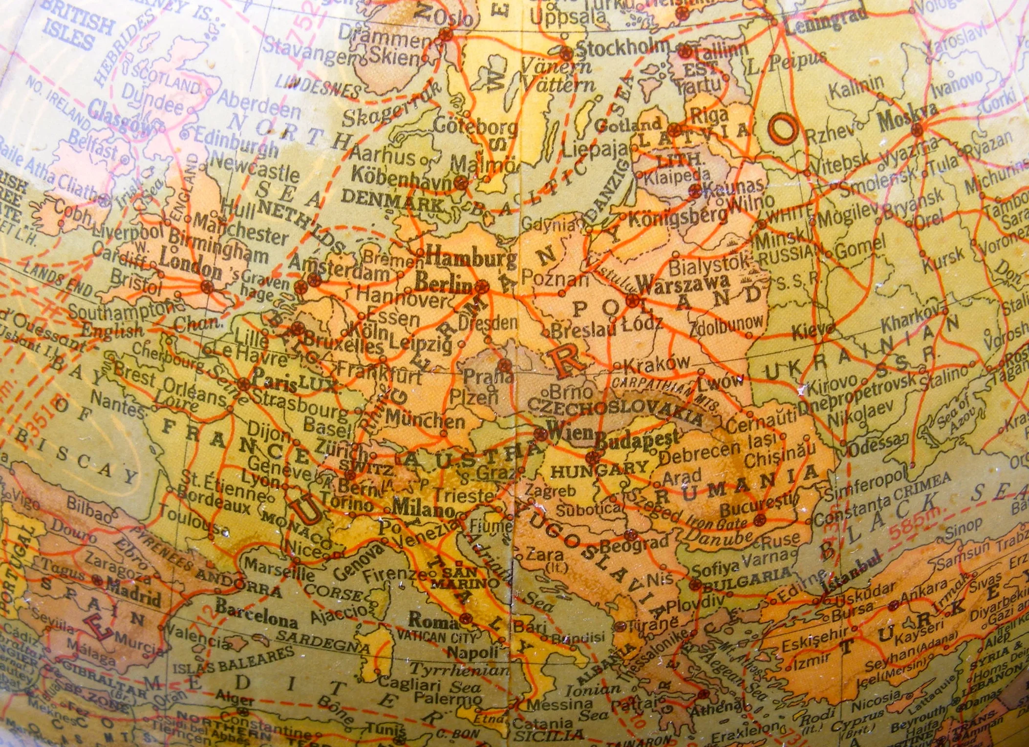
The map identifies the dawn of WW2; Italian East Africa has just been created and is interestingly marked Italian Empire, though Germany has not yet annexed Austria.
With this artifact you will also receive its original box. There it has been stored since 1936. Perfectly contained, the sphere is in perfect condition with one exception: The shellac, which is a natural material, has still its hi-gloss finished, but browned (aged) in various areas, making the patina rather uneven. This can be corrected by removing the finish. On the other hand, we feel this model is so pristine and original as an artifact can rarely be found, it should remain as such.
A fine piece, in style and history and desirable addition to any collection.
C.S. Hammond & Co. 1900 - current New York, Brooklyn & Boston
Founded by Caleb Stillson Hammond in 1900, and formally incorporated in 1901, the company has been known over much of its history as C.S. Hammond & Co. C.S. Hammond began work in New York City, well-known for its extensive line of world, historical, school and thematic atlases and globes, but the company had issued a wide variety of other cartographic items, including maps and transparencies during the last 100 years. It has also printed numerous other works, primarily for the educational market. In addition to its own imprints, Hammond's cartographic output has been included in the encyclopedias, almanacs, dictionaries, Bibles and textbooks of many other publishers. However, globes were outsourced to both, English and Chicago Globemakers.
In its heyday in the early 1960s, Hammond employed 120 draftsmen, artists and researchers at its comfortable, paneled offices an easy walk from the quaint Maplewood village center.
Now the maps are reproduced by a half-dozen computer technicians at a generic office complex in Springfield (and reviewers say the quality of the maps remains high). The only person left who remembers Hammond of the old days is an elderly secretary.
There is still a Hammond World Atlas Corp., but the company is now a wholly owned subsidiary of Langenscheidt Publishing Group, a German publishing behemoth whose other acquisitions include Hagstrom Maps, American Map Corp., Berlitz and the World Almanac.
The Globe itself is made paste-board. The Base is made of black Bakelite with silver details. The non-numeric half meridian consists of hollow aluminum. Travel routes and distances are identified in nautical miles. The ornate and unusual cartouches show sea serpents and a Spanish Clipper. Diameter of the Globe is 12 inches with a total height of about 15.5 inches.
The globe is in absolute perfect condition with one minor flaw. The shellac has aged uneven and spotty. Details are very visible and crisp, colors brilliant. Base and Meridian are in excellent condition.
The age of the Globe has been determined by the political borders displayed, which are as follows:
Europe is shown in its borders prior to WWII. Austria has not yet been annexed by Germany (1938). Czechoslovakia is still in existence as Germany has not yet seized part of what’s today the Czech Republic (1939). Ireland is also shown as Irish Free State.
Middle East-Asia:
Iran has replaced Persia (1935). Palestine is shown instead of Israel (ch 1948). Jordan is called Transjordan. Tenna Tuva is visible (annexed by the USSR in 1944). Instead of Indonesia the Netherlands Indies are shown. Today’s Malaysia is shown as the Malay States. Thailand is still shown as Siam (1939). Vietnam, Laos and Cambodia are shown as French Indochina. Korea is shown as Chosen instead and Manchuria is displayed as Manchukuo (name change occurred during Japanese occupation 1931-45).
Colonies are displayed as follows: French West as well as Equatorial Africa, Angelo-Egyptian Sudan, British, Italian and French Somaliland. Tanganyika Territory and the Belgian Congo are shown; Rhodesia is divided into North and South. Interestingly Italian East Africa (1936-41) is described as the Italian Empire of East Africa.
Well packed, this artifact and box will ship domestic for $20.00, international $65.00 (most countries)
$369 SKU# 914HAMMBAKE36
sold out