A handsome c 1936 (pre WW2) German terrestrial Globe with exceptionally detailed map including Zeppelin Routes


A handsome c 1936 (pre WW2) German terrestrial Globe with exceptionally detailed map including Zeppelin Routes
$0.00
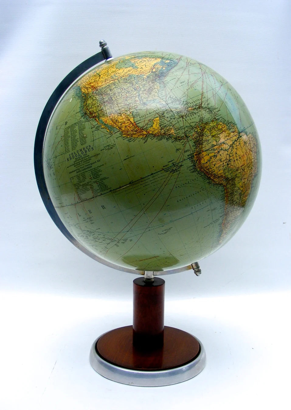
An original German pre WW2 terrestrial Globe, reflecting the world as envisioned by the German Reich of c 1936 ( but far from reality).
The map of this artifact is exceptionally detailed, identifying everything from Zeppelin and early transatlantic “air boat”flights (airplanes landing on water)as well as agricultural product of each region, oil fields, asbestos, diamond and coal mines world wide, just to mention a few. The legend also identifies tribes in Africa, seal hunting territory and fishing areas. Benefitting from the classic German trade of attention to detail, this ever so precise map will allow hours and hours study, always discovering something new.
We will offer a translation into English of the legend, to ensure you truly enjoy this exquisitely detailed map.
The design style of this vintage scientific instrument , minimalistic and sleek, combining the warmth of fruitwood with cool aluminum is classic German. The Bauhaus Style, also known as Modernist and Machine Age, emerged in the early 1900’s in the Berlin area at the Weimar Bauhaus School of Design and lasted several decades. Hitler disapproval of the free -thinking Bauhaus artist lifestyle made them unfortunately to be victims of the SS.
Regardless if one is attracted to this artifact because of its form or function, it is a true piece of history, pleasing to the eye as much as the inquisitive mind.
With this model you will also receive a facsimile of an original advertisement for it.
About the manufacture:
Paul Oestergaard started producing Globes in 1909 with the thought in mind: “A Columbus Globe for every home”. His attention to detail, forward thinking in design and variety of models helped Oestergaard to become one of the top globe makers of his time. He quickly started producing Globes in 24 languages.
In 1942 the company suffered a tremendous loss of people, production buildings and offices due to bombings (during WW2). The family struggled, but diligently continued producing globes by working out of their homes.
Post WW2, the second generation Paul Oestergaard Jr. attempted to locate all former employees to rebuild the Columbus Verlag. However, due to the Russian blockade of Berlin in 1948, most of the facilities were re-located into a politically more stable area in the south of Germany, Stuttgart. This is reflected in the cartouches of the globes as it identifies the location of manufacture. If the cartouche mentions Stuttgart in addition to Berlin, it is a post WW2 Globe. The company is today one of the last family owned globe producers of the world.
The 13” diameter orb itself is covered in twelve individual paper gores. The legend is incedible detailed as it identifies not just political capitols, telegraph lines, caravan, rail, flight and trade routes; it also shows the mining locations of precious metals, vast Agra cultural product of nation’s world wide. The mounting consists of a walnut base in a rich, warm finish with integrated compass, aluminum stamped half meridian and aluminum base brim. This table globe is commanding in size at a total height of 20 inches.
This model is in good condition for its age. Colors are vivid and details are crisp. The finish is still in superb condition. Minor blemishes in form of a wrinkles and scuffing are visible and shown in the photos. The mounting is also in very good condition, no cracks or splits. The walnut base still has it’s original warm finish. A slight indentation to the aluminum band. The compass in the base is functional.
The age of the Globe has been determined by the political borders displayed, which are as follows:
Germany is shown prior to WWII. Austria has not yet been annexed (1938). Czechoslovakia is still visible; part of it has not yet been occupied by Germany (1939). Estonia and Latvia are shown as independent countries instead of being part of the USSR. Istanbul in Turkey is also shown in its old name Constantinople...
Middle East-Asia: Manchuria of China is shown to be owned by Japan instead and re-named Mandschutikuo (German spelling). The Marshall Islands as well as the Caroline Islands are shown under Japanese mandate. What is today Thailand, Cambodia, Laos and Vietnam is shown as Siam and French Indo China. India is displayed as British India. Pakistan is not in existence. Iran is no longer shown as Persia. Today’s Israel is still visible as Palestine.
As mentioned before, German East and South-West Africa is visible. Germany had to surrender these colonies after WW1 as a part of the treaty of Versailles. Anglo-Egyptian Sudan, Belgian Congo, French West and Equatorial Africa are visible in addition to French, British and Italian Somaliland. Abbesinien (Ethiopia) is not yet marked Italian East Africa but identified to be under Italian control(1936-41). Interestingly, Kenya – Colony is displayed and Tanganyika Territory is also identified to be German East Africa. German South West Africa is also shown.
No matter if you are an early aviation, WW2 History or fine Design aficionado, this handsome master piece will meet all those needs and more.
Well packed this artifact will ship domestic for $29, $65 international.
$565 SKU 914COL20036
sold out